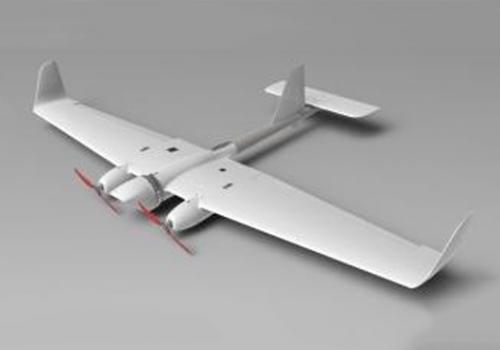
Tactical unmanned aerial systems "Busel"
FAMILY OF UNMANNED AERIAL SYSTEMS “BUSEL”, “BUSEL M”, “BUSEL M50” FOR TERRAIN VIDEO MONITORING
Application:
Video monitoring of terrain and objects, tracking of moving objects from board of unmanned aerial vehicle (UAV) and transmission of video data received via radio channel to ground control station (GCS) and to other remote users in a close to real time mode.
Capabilities:
Depending on installed payload unmanned aerial systems (UAS) belonging to “mini” class with flight range from 20 to 70 km can perform photo, video, infrared and multispectral recording in daylight and nightlight hours using optical systems installed on gyro-stabilized platform. A wide range of payload capabilities and high aerodynamic characteristics of UAV enable using UAS “Busel”, “Busel M”, “Busel M50” for detection of emergency situations, monitoring of condition of territories with oil and gas pipelines, for anti-pouching, animal registration, monitoring of road traffic (with automatic tracking of objects), state borders control, monitoring of condition of power lines and agricultural lands etc.
System composition:
- UAV (up to 5);
- mobile or portable GCS;
- module of receiving-transmitting equipment (up to 2 sets) ;
- standard set of payload (gyro-stabilized infrared photo, video and multispectral camera);
- spare parts, tools and accessories kit;
- set of operational documentation.
Technical characteristics of UAV’s family for terrain video monitoring “Busel”, “Busel M”, “Busel M50 of “mini” class
|
Technical characteristics |
“Busel” |
“Busel M” |
“Busel M50” |
|
Power unit |
2 electro motors |
||
|
Maximum take-off weight, kg |
up to 6 |
up to 10 |
up to 14 |
|
Full wing span, mm |
2335 |
2420 |
3470 |
|
Flight time, min |
up to 60 |
up to 120 |
up to 150 |
|
Flight speed range, km/h |
40–100 |
60–120 |
60–100 |
|
Maximum flight altitude, m |
up to 1500 |
up to 4000 |
up to 5000 |
|
Maximum flight range, km |
20 |
50 |
70 |
|
Payload gyro-stabilized |
platform; TV, photo, IR or multispectral camera |
||
|
Flight navigation system |
GPS and autopilot |
GPS, GLONASS and autopilot |
|
|
Take-off/landing way |
by hand / parachute |
||
