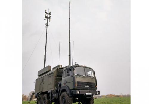
Automated control post “Berezina”
Designation:
- control of jamming stations of VHF/HF radio communication “Groza”, “Purga”;
- control of direction finders of VHF/HF band “Grif”, “Zhuravl”;
- automatic data exchange with similar control post.
Automated control post provides:
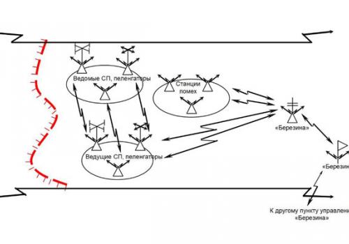
1. Centralized control of jamming stations of VHF/HF band “Groza”, “Purga”, direction finders of HF/VHF band “Zhuravl” and “Grif” (up to 5 (6) primary jamming stations and direction finders) while working in the mode of tactical control post:
- automatic by request collection, processing and storage of the data about frequencies and bearings of detected radio emission sources from subordinated jamming stations and direction finders;
- calculation of the sources’ coordinates by the received bearing values;
- automatic by request collection of frequencies and coordinates of detected radio emission sources from subordinated jamming stations and direction finders.
- target distribution and target detection output to subordinated jamming stations.
2. Automated data exchange with similar control posts, which perform functions of subordinated (tactical) and superior control post (control post of battalion commander):
- transmission of the data about radio electronic situation and reports to superior control post of battalion commander and reception of the commands and information of tactical and radio electronic situation, its display and documentation in the mode of tactical control post;
- reception of the data about radio electronic situation and reports from inferior tactical control posts, its display and documentation, transfer of commands, data about tactical and radio electronic situation to inferior control posts in the mode of control post of battalion commander.
It is possible to provide data exchange with superior control post of the Customer after agreeing on the type of hardware of data transmission link and information exchange protocol.
Capabilities
Control post should provide the operation of subordinated jamming stations and direction finders in the following modes:
"Preparation";
"Radio reconnaissance";
"Radio suppression" (only for jamming stations).
Control post should be able to fulfill the following tasks:
1) input of initial data:
- input into memory, selection, storage, display on the screen, correction (editing) of initial data by composition of the complex, condition of its elements and their location;
- input into memory, storage, display on the screen and editing of characteristics of tactical and radioelectronic situation;
- input and refinement (editing) of frequencies prohibited for suppression (frequency ranges);
- input and refinement (editing) of ranges and sectors of radio reconnaissance for jamming stations and direction finders and radio suppression (only for jamming stations);
2) calculation and information tasks:
- calculation of time for the arrangement of radio suppression;
- input and refinement (editing) of the borders of positioning areas for complex means;
- automated calculation of distances between two points on the ground and calculation of length of the broken line (of the route) on the ground;
- automated calculation of azimuths (bearings) from jamming stations to any graphically assigned point on the ground;
- automated calculation of lines of sight of jamming stations and direction finders;
- automated calculation of energy availability of jamming stations by zones;
- automated calculation of energy availability of jamming station by communication units;
- automated calculation of zones of equal errors of coordinates determination of radio emission sources;
- development of typical combat documents with the use of patterns and text editor, and also their print by the printing device;
- automated identification of radio emission sources;
- automated detection of radio emission sources in the areas of special attention and in the communication units;
- automated detection of joint use of frequencies by different radio emission sources and disclosure of simplex radio networks and communication units;
- automated assignment of radio suppression priorities to objects;
3) control:
- automated test of intracomplex communication;
- assignment of frequencies prohibited for suppression (frequency ranges);
- assignment of radio reconnaissance ranges and sectors for jamming stations and direction finders and radio suppression (only for jamming stations);
- automated switch of subordinated jamming stations and direction finders in different operation modes (“Preparation”, “Radio reconnaissance” and “Radio suppression”);
- automated collection and accumulation of reconnaissance data received from jamming stations and direction finders;
- automated transfer of target pointing data for radio reconnaissance to controlled jamming stations and direction finders;
- automated target distribution of radio suppression objects between jamming stations;
- manual input of frequencies for radio suppression;
- automated assignment and transfer of the list of frequencies for radio suppression to jamming stations;
- analysis of the results of radio suppression of radio emission sources transferred from jamming stations and repeat of target distribution;
- control of the presence of interferences on the jamming frequencies assigned by jamming stations within the range of 1,5-6000 MHz (using radio receiver).
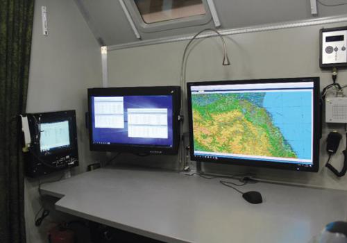
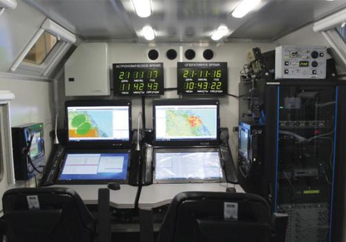
The elements of radio electronic situation and the results of graphical designed tasks should be displayed on the background of electronic map of the area. At the same time the enlargement and diminution of the map should be provided without restrictions, and also capability to solve tasks related to the use of the matrix of heights.
Special software when calculating location of radio emission sources should take into account the sphericity of the earth.
In order to display the elements of radio electronic situation and the results of graphical designed tasks on the electronic map from the Customer it is required to provide the electronic map with resolution of *.map (*.sxf) scale 1:200 000.
